Alquié, Lustbarkeiten des Königreichs Franckreich, oder außführliche Beschreibun
€ 380,--
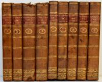
Alquié, François Savinien d’: Lustbarkeiten des Königreichs Franckreich, oder außführliche Beschreibung aller in demselben befindlichen Provintzien, Städte, Erz-Bißthümer, Bißthümer, Stiffter, Kirchen, dessen Macht und Einkommen, Parlamenten. Benebenst einer Genealogi und Stamm-Register aller Könige […] und Kupffer-Figuren der vornehmsten Städte. In Teutscher und Frantzösischer Sprach, allenso in Franckreich reysen, sehr nützlich und nothwendig. Franckfurt, Verlag Wilhelm Serlin, 1671. 8°. 17,5 x 11 cm. [3] Blatt, 1067 Seiten, [6] Blatt. Frontispiz, 1 Faltkarte und 31 (von 36) gefalteten Kupfertafeln. Halblederband der Zeit auf 5 Bünden mit reicher Rückenvergoldung, goldgeprägtem Titel auf Lederrückenschild und Rundum-Rotschnitt.